Yesterday’s post (which should have been Tuesday’s), Wanderlust, Memories and Spirits of Place – Against a Backdrop of Times Before COVID-19, was only a small slice of my travels over the past decade or so. There are so many other places that I have traveled, where the pull of Spirits of Place was immensely strong. Some were in the oddest places. Some, I have suspicions that it may not be the Spirits of Place that still haunt the areas.
I have already made my love of driving known. I seriously have no issues pulling long drive of twelve to fourteen hours before I need some kind of lengthy rest. In the past, I have made long drives from the north area of Dallas to just north of Kansas City in a single night of driving. Part of that drive is through a tolled section of Interstate-35, which is mostly a rather boring drive that is punctuated throughout with overtly right-wing Christian signs denouncing abortion. Those signs are placed on the private property that borders either side of the roadway. However, there is a section of the drive where the landscape changes dramatically. This is the Flint Hills region of Kansas, and it is a magnificent part of the drive. The interstate winds down into the Flint Hills and the back up other hills. Unlike the majority of the turnpike going north, this is not a straight line of driving. All around you, on either side of the road, is miles upon miles of prairie land. Occasionally, you can see animals in the distance, but it is essentially clear, flat-land for the most part. Most of the commercial signage also disappears here, as well as a huge amount of the done-in-the-garage anti-abortion signs. Plus, there is also the strong pull of the Spirits of the Land here. Even with an interstate and barbed-wire fencing, this area has that strong feeling of power. Anytime I have driven north or south through this area, this particular part of the drive has always been my favorite. I always exit the Flint Hills part of the interstate with a feeling of energized power, which I have no explanation of. For reference, this is the ancestral lands of a few First nations peoples including the Kaw, Kikaapoi, Oceti Sakowin (Sioux), and the Osage.
When I was stationed in Germany, in 1992, it was a few years after the fall of the Berlin Wall. When I was younger and living in Germany while my father was stationed at Weisbaden, we never took the chance for a visit to Berlin. Thanks to military mission that I was attached to, I got that chance in April of 1992. We didn’t get the chance to stay very long, only three days, However, we all took the opportunity to visit the remains of the Wall, as well as Checkpoint Charlie. We were not allowed to bring cameras with us, so those of us that went did not have anything but our memories to carry back with us. I remember thinking how different life was on each side of that wall. On the West Germany side, apartments and shop fronts were as close as ten to fifteen feet from the Wall. On the opposite side…mostly guard stations and barbed wire. Over the years, there were many attempts by East Germans to scale, tunnel or circumvent the wall to a freer society in West Berlin. Most were stopped and taken to prisons or killed in their escapades. While visiting, I felt strong presences there. Many of them. These did not have the same feeling of Spirits of Place. It was more as if they were there because they had nowhere else to go. To this day, I wonder if I could still feel those presences so near the foreboding Wall that separated Germans from Germans, sometimes splitting families in two.
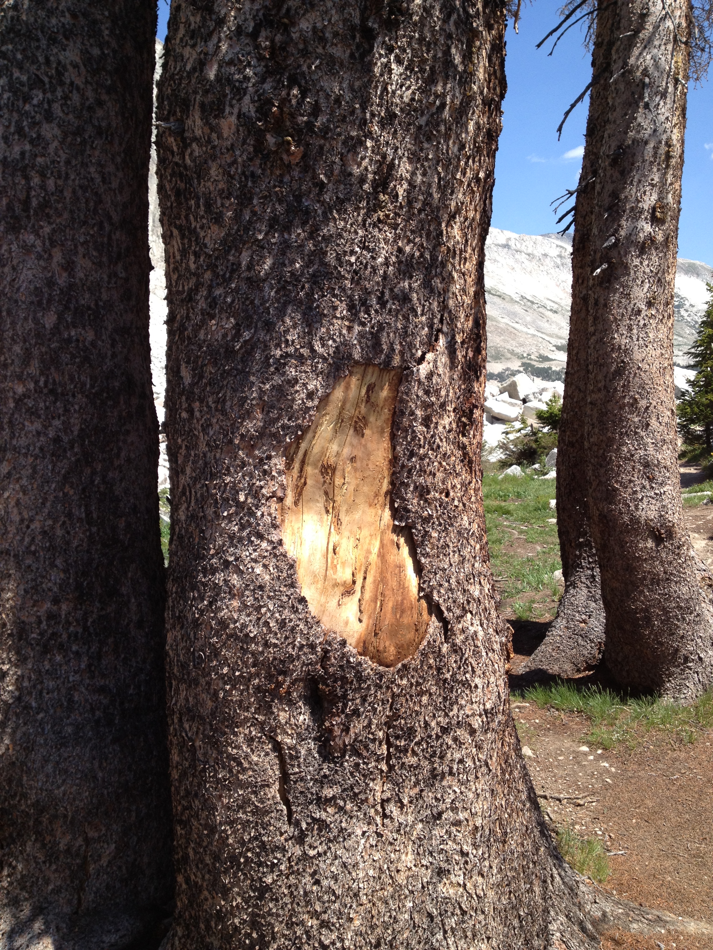
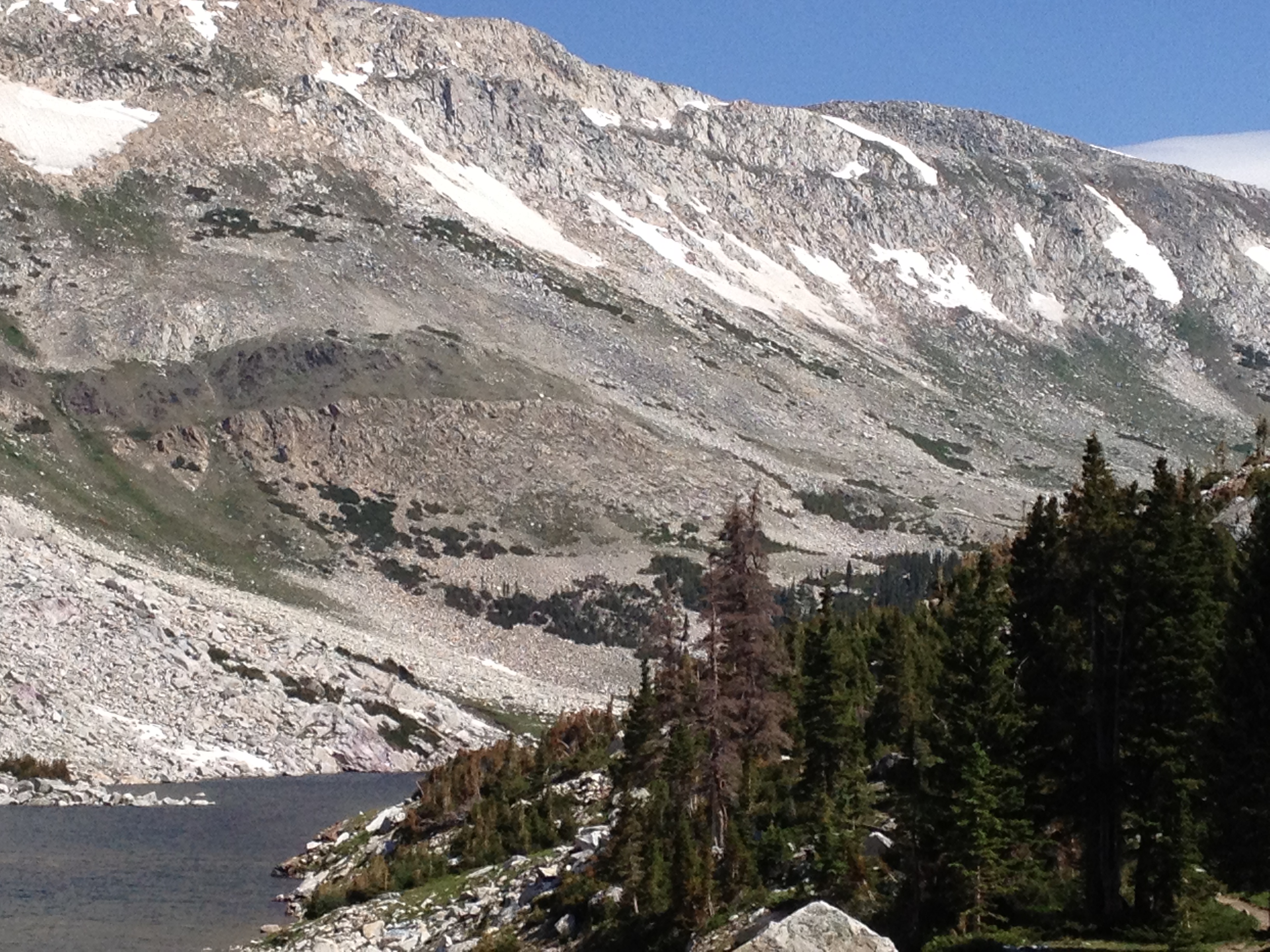
Another place that I ventured to was Medicine Bow Peak near Laramie, Wyoming. On October 6th, 1955, a United DC-4 crashed into Medicine Bow Peak killing all 63 passengers and 3 crew members aboard. The aircraft was traveling from New Your City to San Francisco, California and had made a stop in Denver, Colorado for a routine crew change. Assigned to an altitude of 10,000 feet, the plane was to fly through the Rocky Mountains along a path that kept it away from mountains taller than the assigned altitude. There is; however, a narrow shortcut through the northern tier of the Rockies that can be flown, that would reduce the flight time to Seattle by nearly ninety minutes. As there was a lengthy delay in Denver, it is assumed that this was the reasoning that the crew deviated from the flight plan and attempted the shortcut, in order to get the flight back on scheduled time. Instead, they fly straight into Medicine Bow Peak, a mountain of some 12,000 feet in height. When I visited the area, I was struck by the number of boulders strewn all around the area below the summit. About a mile away from the crash site, there is a paved road (back in 1955 this entire area was wilderness with no roads – paved or otherwise) which leads to a parking area with many picnic benches. The day I was there, it was very sunny, and extremely warm. Plus, there were no other people at this location. The hike alone the well-worn path was a nice stroll, with the exception of coming across a tree with deep claw slashes in it, which appeared to be fresh. This was the sign of a bear marking its territory. Keeping that in mind, the rest of the walk was rather brisk and a bit short, leading to the location where the aircraft had slammed into the sheer face of the summit. In this particular place, the Spirits of Place were extremely strong, and I wondered what it might have been like here long before the pavement invasion of the white man. These lands are the ancestral home of the Arapaho, Cheyenne, and Oceti Sakowin (Sioux). All three of these tribes figure prominently in the retelling of Hollywood versions of the time of the first white Settlers in the west. Early history of Medicine Bow Peak is not known prior to the 1833 and 1834 expeditions of John C. Fremont within this area. Down in the foothills, the Lakota, Ute and Eastern Shoshone were known to have also inhabited the area or utilized the canyons and mountain passes as travel routes to and from Summer and Winter lands.
Each of these locations hold vivid memories in my mind. Both the Flint Hills and Medicine Bow Peak have often left me wondering what the area must have been like before the coming of the white Settlers. While most of my musings likely have a heavy tinge of romanticism attached to them, I do understand how rough life would have been. Still, I envy the sheer closeness that comes with being so close to nature. Even under the auspices of such terrifying ferocity that was surely evident from the various predators that lived there.
I have so many more memories of pre-COVID travel, but I am also reminded about the one rule I have made for myself when visiting these places, even man-made places such as the Berlin Wall: leave no trace. At Medicine Bow Peak, if you walk on the other side of the lakes formed by ice and snow run-off, you can still find parts and pieces of United Airlines Flight 409 among the rocks and boulders. The plea from many folks is to leave it where it is found. Photograph it, but don’t pick it up. Leave it there, so others may have the chance to experience the “discovery” of such things for themselves. Bring in food, at your own discretion and caution. And by all means, if you bring it in, pack it back out with you. Dispose of your trash where it should be…not just letting it fall out of your hands casually. Let others have the same or even better experience than you did.
COVID-19 will not be here holding us all hostage in our homes forever. Much like influenza, a work-around will be found. We do not have a cure for influenza, but we do have a yearly vaccine that helps control its spread and its effects on the human body. We will eventually reach that point with COVID-19. It probably won’t happen as soon as many would like, but I am hopefully that it will happen. In the meantime, we stay safe. We wear our masks in public. We keep our distance from others, as much as we possibly can. We thoroughly wash our hands. And we practice patience, as best we can.
–T /|\